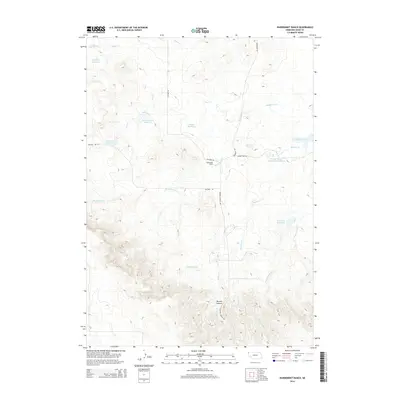
2014 Map of Warbonnet Ranch
USGS Topo · Published 2014About this map
Warbonnet Ranch lies at the heart of this rangeland landscape in Sioux County, where water management is central to the survival of high-plains agriculture. A sophisticated network of catchments including Shepherd Reservoir, Snyder Reservoir, and Little Red Reservoir suggests a long history of water conservation and livestock management. These reservoirs are strategically placed along seasonal drainage systems like Warbonnet Cr and Prairie Dog Cr, which carve through the undulating terrain.
Find a feature on this map
23 named features on this map. Tap any name to fly to it.
Don’t see what you’re looking for? This feature index may not catch every label — zoom into the map to look around manually.
Map Details
Editions of this 2014 Warbonnet Ranch Map
This is the sole edition of this map. No revisions or reprints were ever made.
Other maps of this area

1954 · Torrington
USGS Topo · 1:250,000

1955 · Alliance
USGS Topo · 1:250,000

1957 · Alliance
USGS Topo · 1:250,000

1958 · Torrington
USGS Topo · 1:250,000

1958 · Alliance
USGS Topo · 1:250,000

1977 · Van Tassell
USGS Topo · 1:24,000

1978 · Harrison West
USGS Topo · 1:24,000
1978 · Sherrill Hills
USGS Topo · 1:24,000

1978 · Kirtley
USGS Topo · 1:24,000

1979 · Harrison East
USGS Topo · 1:24,000