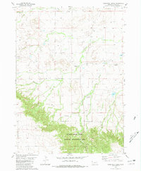
1980 Map of Warbonnet Ranch
USGS Topo · Published 1981About this map
Gilbert-Baker State Wildlife Management Area anchors the southern portion of this landscape in Sioux County, where the topography shifts from open rangeland into the complex drainages of Monroe Canyon. The map reveals a remote ranching economy defined by vast distances between established headquarters like the Warbonnet Ranch and Shalimar Ranch. Water management is central to life here, evidenced by numerous tanks scattered across the high plains to support livestock. A dense network of seasonal and perennial waterways, including the curiously named Dirty Jim Creek and Prairie Dog Creek, carves through the terrain, eventually converging toward the larger Warbonnet Creek. The inclusion of a Campground near Monroe Creek suggests the area's dual role as both working cattle country and a destination for public recreation and conservation.
Find a feature on this map
18 named features on this map. Tap any name to fly to it.
Don’t see what you’re looking for? This feature index may not catch every label — zoom into the map to look around manually.
Map Details
Editions of this 1980 Warbonnet Ranch Map
This is the sole edition of this map. No revisions or reprints were ever made.
Other maps of this area

1954 · Torrington
USGS Topo · 1:250,000

1955 · Alliance
USGS Topo · 1:250,000

1957 · Alliance
USGS Topo · 1:250,000

1958 · Torrington
USGS Topo · 1:250,000

1958 · Alliance
USGS Topo · 1:250,000

1977 · Van Tassell
USGS Topo · 1:24,000

1978 · Harrison West
USGS Topo · 1:24,000
1978 · Sherrill Hills
USGS Topo · 1:24,000

1978 · Kirtley
USGS Topo · 1:24,000

1979 · Harrison East
USGS Topo · 1:24,000