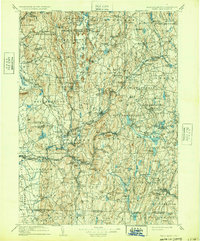
1908 Map of Ware
USGS Topo · Published 1932About this map
Swift River and Ware River define the industrial and agricultural landscape of central Massachusetts as it appeared before the mid-century creation of the Quabbin Reservoir. This document captures the original locations of settlements like North Dana, Greenwich Village, Greenwich, and Enfield—places that were later submerged or dismantled for the watershed. The topography is dotted with family-named hills and vital transport hubs, including New Braintree Sta and the junction of the Boston and Albany RR.
Find a feature on this map
167 named features on this map. Tap any name to fly to it.
Don’t see what you’re looking for? This feature index may not catch every label — zoom into the map to look around manually.
Map Details
Editions of this 1908 Ware Map
2 editions found

Other maps of this area

1885 · Northampton
USGS Topo · 1:62,500

1885 · Worcester
USGS Topo · 1:62,500

1886 · Springfield
USGS Topo · 1:62,500

1886 · Worcester
USGS Topo · 1:62,500

1886 · Northampton
USGS Topo · 1:62,500

1887 · Brookfield
USGS Topo · 1:62,500

1887 · Warwick
USGS Topo · 1:62,500

1887 · Palmer
USGS Topo · 1:62,500

1887 · Belchertown
USGS Topo · 1:62,500

1887 · Winchendon
USGS Topo · 1:62,500