
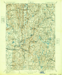
1908 Map of Ware
USGS Topo · Published 1908About this map
The West Branch Swift River, Middle Branch Swift River, and East Branch Swift River define the valley before the creation of the Quabbin Reservoir, showing the towns of Enfield, Greenwich, Prescott, and Dana as they functioned in the early twentieth century. This landscape is a complex network of hill-country settlements like Millington and Moores Corners, connected by the Central Vermont RR as it follows the river south toward Ware. Further south, industrial and transit hubs like Palmer and Three Rivers emerge at the confluence of the Ware River and Chicopee River. Notable local landmarks include the State Almshouse near Tewksbury and the Holyoke Range rising to the west. The map documents numerous small school districts and villages such as Dudleyville, Packardsville, and Smiths, many of which would later be subsumed by utility and infrastructure projects.
Find a feature on this map
219 named features on this map. Tap any name to fly to it.
Don’t see what you’re looking for? This feature index may not catch every label — zoom into the map to look around manually.
Map Details
Editions of this 1908 Ware Map
2 editions found
Other maps of this area

1885 · Northampton
USGS Topo · 1:62,500

1885 · Worcester
USGS Topo · 1:62,500

1886 · Springfield
USGS Topo · 1:62,500

1886 · Worcester
USGS Topo · 1:62,500

1886 · Northampton
USGS Topo · 1:62,500

1887 · Brookfield
USGS Topo · 1:62,500

1887 · Warwick
USGS Topo · 1:62,500

1887 · Palmer
USGS Topo · 1:62,500

1887 · Belchertown
USGS Topo · 1:62,500

1887 · Winchendon
USGS Topo · 1:62,500