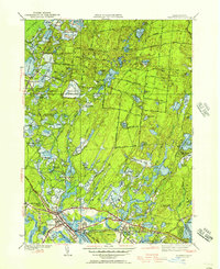
1946 Map of Wareham
USGS Topo · Published 1957About this map
Myles Standish State Forest dominates the northern landscape of this mid-century survey, a sprawling wooded area defined by dozens of small kettle ponds and early forestry roads like Federal Road and Halfway Road. The southern portion of the quadrangle reveals the intensive agricultural development of the region, where a complex network of wetlands has been converted into industrial-scale berry production. Names like Wankinco Cranberry Bog, Frogfoot Cranberry Bogs, and Federal Bogs signal the economic importance of this specialized crop to the Wareham and South Carver communities.
Find a feature on this map
104 named features on this map. Tap any name to fly to it.
Don’t see what you’re looking for? This feature index may not catch every label — zoom into the map to look around manually.
Map Details
Editions of this 1946 Wareham Map
This is the sole edition of this map. No revisions or reprints were ever made.
Other maps of this area

1885 · New Bedford
USGS Topo · 1:62,500

1885 · Middleboro
USGS Topo · 1:62,500

1886 · Falmouth
USGS Topo · 1:62,500

1886 · Plymouth
USGS Topo · 1:62,500

1888 · New Bedford
USGS Topo · 1:62,500

1888 · Falmouth
USGS Topo · 1:62,500

1888 · Middleboro
USGS Topo · 1:62,500

1889 · Plymouth
USGS Topo · 1:62,500

1893 · Middleboro
USGS Topo · 1:62,500

1893 · Falmouth
USGS Topo · 1:62,500