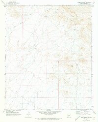
1970 Map of Warm Springs SE
USGS Topo · Published 1973About this map
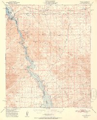
Warm Springs Wash cuts through the northwest corner of this Mohave County desert landscape, reflecting a 1970 snapshot of geological exploration and remote navigation. The terrain is defined by a series of exploration markers and extraction efforts, including a Mine, a Prospect, and the prominent Warm Prospect located in the southeastern quadrant. These features, along with numerous Drill Hole locations scattered across the high ground, suggest an era of active mineral surveying. Transport through the area is limited to a network of a Jeep Trail, illustrating the difficult accessibility of the region. Distinctive landmarks like the Sphinx peak provide topographic orientation in a landscape marked by complex township and range boundaries, including the rare T. 16 1/2 N township line.
Find a feature on this map
10 named features on this map. Tap any name to fly to it.
Don’t see what you’re looking for? This feature index may not catch every label — zoom into the map to look around manually.
Map Details
Editions of this 1970 Warm Springs SE Map
This is the sole edition of this map. No revisions or reprints were ever made.
Other maps of this area

1903 · Needles
USGS Topo · 1:125,000

1904 · Needles Special
USGS Topo · 1:125,000
1927 · Yucca
USGS Topo · 1:62,500

1927 · Buck Mountains
USGS Topo · 1:62,500

1929 · Buck Mountains
USGS Topo · 1:62,500
1929 · Yucca
USGS Topo · 1:62,500

1943 · Topock
USGS Topo · 1:62,500
1950 · Topock
USGS Topo · 1:62,500
1951 · Topock
USGS Topo · 1:62,500

1954 · Needles
USGS Topo · 1:250,000