
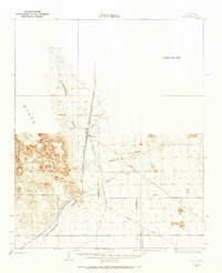
1927 Map of Buck Mountains
USGS Topo · Published 1966About this map
Buck Mountains rise abruptly from the surrounding desert floor in this late 1920s topography, serving as a prominent landmark for early cross-country travelers. The presence of the National Old Trails Highway and the Yucca Cutoff illustrates the transition from pioneer wagon roads to early automobile transit through Mohave County. Mining activity is evident on the mountain flanks at the Palo Verde Mine and the Arizona-Yucca Mine, indicating the localized prospecting and extraction occurring in the region. To the west, the broad Sacramento Wash drainage parallels the tracks of the A T & S F railroad, while the eastern portion of the map transitions into the wide expanse of Dutch Flat. This survey highlights the intersection of early industrial infrastructure and the high desert landscape, with much of the southern portion of the sheet remaining as a documented Unsurveyed Area at the time.
Find a feature on this map
15 named features on this map. Tap any name to fly to it.
Don’t see what you’re looking for? This feature index may not catch every label — zoom into the map to look around manually.
Map Details
Editions of this 1927 Buck Mountains Map
This is the sole edition of this map. No revisions or reprints were ever made.
Other maps of this area

1903 · Needles
USGS Topo · 1:125,000

1904 · Needles Special
USGS Topo · 1:125,000

1911 · Parker
USGS Topo · 1:125,000

1923 · Signal
USGS Topo · 1:250,000
1927 · Yucca
USGS Topo · 1:62,500

1929 · Buck Mountains
USGS Topo · 1:62,500
1929 · Yucca
USGS Topo · 1:62,500

1942 · Signal
USGS Topo · 1:250,000

1943 · Giers Basin
USGS Topo · 1:62,500

1943 · Topock
USGS Topo · 1:62,500