
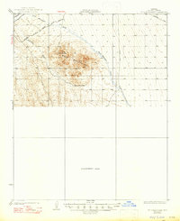
1929 Map of Buck Mountains
USGS Topo · Published 1929About this map
Mining operations and early motor routes define this desert landscape surveyed during the late 1920s. The Palo Verde Mine and Arizona-Yucca Mine are positioned on the southern slopes of the Buck Mountains, illustrating the era's industrial activity in Mohave County. In the north, the National Old Trails Highway runs parallel to the At & SF tracks, serving as a primary corridor for transcontinental travel before the advent of the modern interstate system.
Find a feature on this map
13 named features on this map. Tap any name to fly to it.
Don’t see what you’re looking for? This feature index may not catch every label — zoom into the map to look around manually.
Map Details
Editions of this 1929 Buck Mountains Map
2 editions found
Other maps of this area

1903 · Needles
USGS Topo · 1:125,000

1904 · Needles Special
USGS Topo · 1:125,000

1911 · Parker
USGS Topo · 1:125,000

1923 · Signal
USGS Topo · 1:250,000
1927 · Yucca
USGS Topo · 1:62,500

1927 · Buck Mountains
USGS Topo · 1:62,500
1929 · Yucca
USGS Topo · 1:62,500

1942 · Signal
USGS Topo · 1:250,000

1943 · Giers Basin
USGS Topo · 1:62,500

1943 · Topock
USGS Topo · 1:62,500