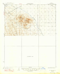
1929 Map of Buck Mountains
USGS Topo · Published 1947About this map
Mining operations and early transcontinental travel routes dominate this survey of the Arizona desert conducted in the late 1920s. The Palo Verde Mine and the Arizona-Yucca Mine are prominent fixtures within the Buck Mountains, representing the era's mineral extraction efforts in Mohave County. This landscape is a corridor for essential transportation, featuring the At & Sf railroad and the National Old Trails Highway, a predecessor to the famous Route 66.
Find a feature on this map
14 named features on this map. Tap any name to fly to it.
Don’t see what you’re looking for? This feature index may not catch every label — zoom into the map to look around manually.
Map Details
Editions of this 1929 Buck Mountains Map
2 editions found
Other maps of this area

1903 · Needles
USGS Topo · 1:125,000

1904 · Needles Special
USGS Topo · 1:125,000

1911 · Parker
USGS Topo · 1:125,000

1923 · Signal
USGS Topo · 1:250,000

1927 · Yucca
USGS Topo · 1:62,500

1927 · Buck Mountains
USGS Topo · 1:62,500

1929 · Buck Mountains
USGS Topo · 1:62,500

1929 · Yucca
USGS Topo · 1:62,500

1942 · Signal
USGS Topo · 1:250,000

1943 · Giers Basin
USGS Topo · 1:62,500