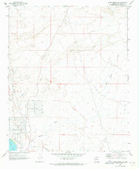
1970 Map of Warm Springs SW
USGS Topo · Published 1973About this map
Havasu Valley and the surrounding desert terrain are the focal points of this 1970 landscape, where the arid environment meets modern development. In the southwestern corner, the planned residential streets of the Golden Shores area appear, featuring thoroughfares like Golden Shores Parkway and Casa Grande Drive. This community borders the Havasu National Wildlife Refuge, which protects the wetlands and riparian habitat of Topock Marsh and the Fort Mojave Indian Reservation.
Find a feature on this map
27 named features on this map. Tap any name to fly to it.
Don’t see what you’re looking for? This feature index may not catch every label — zoom into the map to look around manually.
Map Details
Editions of this 1970 Warm Springs SW Map
This is the sole edition of this map. No revisions or reprints were ever made.
Other maps of this area

1903 · Needles
USGS Topo · 1:125,000

1904 · Needles Special
USGS Topo · 1:125,000

1943 · Topock
USGS Topo · 1:62,500

1950 · Topock
USGS Topo · 1:62,500

1950 · Sawtooth Range
USGS Topo · 1:62,500

1950 · Needles
USGS Topo · 1:62,500

1951 · Topock
USGS Topo · 1:62,500

1951 · Sawtooth Range
USGS Topo · 1:62,500

1952 · Needles
USGS Topo · 1:62,500

1954 · Needles
USGS Topo · 1:250,000