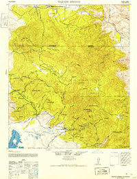
1952 Map of Warner Springs
USGS Topo · Published 1952About this map
The high desert and mountain interface of northern San Diego County is documented here during the early 1950s, centering on the historic resort community of Warner Springs. The landscape is defined by the transitions between the Cleveland National Forest and tribal lands, including the Los Coyotes Indian Reservation and Coahuila Indian Reservation. Water is the primary driver of development in this arid region, from the wide expanse of Lake Henshaw to the high-elevation meadows like Cooper Cienaga. Notable human footprints include isolated outposts such as Emery's Service, Holcomb Village, and the remote San Ignacio. The map details a network of primitive transportation routes, including the Chihuahua Road and various truck trails that provided access to fire lookouts and cattle camps across Chihuahua Valley and Durasno Valley.
Find a feature on this map
42 named features on this map. Tap any name to fly to it.
Don’t see what you’re looking for? This feature index may not catch every label — zoom into the map to look around manually.
Map Details
Editions of this 1952 Warner Springs Map
This is the sole edition of this map. No revisions or reprints were ever made.
Other maps of this area

1901 · Southern California Sheet No. 1
USGS Topo · 1:250,000

1901 · San Jacinto
USGS Topo · 1:125,000

1903 · Ramona
USGS Topo · 1:125,000

1904 · Indio
USGS Topo · 1:125,000

1904 · Southern California Sheet No. 2
USGS Topo · 1:250,000

1904 · Southern California Sheet No. 1
USGS Topo · 1:250,000

1931 · Vallecito
USGS Topo · 1:125,000

1939 · Warner Springs
USGS Topo · 1:62,500

1939 · Santa Ysabel
USGS Topo · 1:62,500

1939 · Borrego
USGS Topo · 1:62,500