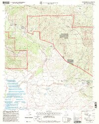
1997 Map of Warner Springs
USGS Topo · Published 2000About this map
San Jose Del Valle Grant dominates the interior of this 1990s revision, a landscape defined by expansive land grants and a network of water resources feeding into Lake Henshaw. The settlement of Warner Springs serves as a focal point near Inspiration Point, while smaller communities like Holcomb Village and Sunshine Summit are established along the higher elevations. The mapping reflects a significant transition in land management and public access, with the Pacific Crest National Scenic Trail winding through the eastern portion of the Cleveland National Forest. Evidence of local community life persists through the presence of the Warner Union School and a Cem, while specialized facilities like the Puerta La Cruz Conservation Camp and Fire CDE Station indicate the region's focus on forest management and conservation at the end of the 20th century.
Find a feature on this map
47 named features on this map. Tap any name to fly to it.
Don’t see what you’re looking for? This feature index may not catch every label — zoom into the map to look around manually.
Map Details
Editions of this 1997 Warner Springs Map
This is the sole edition of this map. No revisions or reprints were ever made.
Other maps of this area

1903 · Ramona
USGS Topo · 1:125,000

1904 · Southern California Sheet No. 2
USGS Topo · 1:250,000

1939 · Warner Springs
USGS Topo · 1:62,500

1939 · Santa Ysabel
USGS Topo · 1:62,500

1939 · Palomar Mountain
USGS Topo · 1:62,500

1942 · Ramona
USGS Topo · 1:62,500

1943 · Santa Ysabel
USGS Topo · 1:62,500

1943 · Warner Springs
USGS Topo · 1:62,500

1947 · Ramona
USGS Topo · 1:62,500

1947 · Santa Ana
USGS Topo · 1:250,000