
1923 Map of Warrenville
USGS Topo · Published 1923About this map
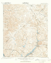
The industrial and educational landscape along the Edgefield Co Aiken Co boundary comes into focus in the early 1920s, anchored by the textile and rail hubs of Graniteville, Warrenville, and Langley. These mill towns are connected by the Southern railroad and the Augusta Aiken Electric Bridge, illustrating a period of rapid development along the Horse Creek valley. Outside these industrial centers, the landscape is defined by a dense network of rural institutions, including Bettis Academy and North Augusta Academy, which served as vital community centers alongside numerous country churches like Science Hill Church and Hammond Grove Church.
Find a feature on this map
69 named features on this map. Tap any name to fly to it.
Don’t see what you’re looking for? This feature index may not catch every label — zoom into the map to look around manually.
Map Details
Editions of this 1923 Warrenville Map
2 editions found
Other maps of this area

1892 · Mc Cormick
USGS Topo · 1:125,000

1912 · Mc Cormick
USGS Topo · 1:125,000

1920 · Aiken
USGS Topo · 1:48,000

1920 · Talatha
USGS Topo · 1:48,000

1920 · Clarks Hill
USGS Topo · 1:48,000

1921 · Augusta
USGS Topo · 1:62,500

1921 · Aiken
USGS Topo · 1:62,500

1921 · Talatha
USGS Topo · 1:62,500

1921 · Clarks Hill
USGS Topo · 1:62,500

1922 · Hephzibah
USGS Topo · 1:62,500