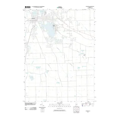
2010 Map of Warsaw
USGS Topo · Published 2010About this map
The northern reaches of Warsaw center on a high concentration of water bodies, including Center Lake, Pike Lake, and the expansive Winona Lake. This glacial landscape is defined by its series of small, named lakes and intricate drainage systems like the Keefer-Evans Ditch and Wyland Ditch, which stitch together a terrain of agricultural fields and residential expansion. Just north of the city center, Oakwood Cemetery serves as a significant genealogical anchor, while the Coolwater Camp Grounds near Whyland Lake point toward the area's long-standing role as a regional recreational hub. The map reveals how the street grid of the city transitions into a more traditional rural section-and-range layout to the south and east, where smaller basins such as Muskellunge Lake and Stafford Lake remain surrounded by open land and family farms along routes like S County Farm Rd.
Find a feature on this map
67 named features on this map. Tap any name to fly to it.
Don’t see what you’re looking for? This feature index may not catch every label — zoom into the map to look around manually.
Map Details
Editions of this 2010 Warsaw Map
This is the sole edition of this map. No revisions or reprints were ever made.
Other maps of this area

1950 · Leesburg
USGS Topo · 1:24,000

1950 · Pierceton
USGS Topo · 1:24,000

1950 · North Webster
USGS Topo · 1:24,000

1953 · Fort Wayne
USGS Topo · 1:250,000

1956 · Fort Wayne
USGS Topo · 1:250,000

1957 · Warsaw
USGS Topo · 1:24,000

1959 · Atwood
USGS Topo · 1:24,000

1961 · Silver Lake
USGS Topo · 1:24,000
1961 · Burket
USGS Topo · 1:24,000
1962 · North Manchester North
USGS Topo · 1:24,000