
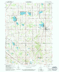
1961 Map of Silver Lake
USGS Topo · Published 1963About this map
The glacial waters of Silver Lake and the Erie-Lackawanna railroad line define the landscape of southern Kosciusko County during the early 1960s. The village of Silver Lake sits as a central hub, flanked by the Township Sch and nearby Silver Creek Ch. The region is a patchwork of small kettle lakes and drainage systems, where Yellow Creek Lake, Beaver Dam Lake, and Diamond Lake provide recreational points such as a Public Fishing Site and a Trailer Park.
Find a feature on this map
51 named features on this map. Tap any name to fly to it.
Don’t see what you’re looking for? This feature index may not catch every label — zoom into the map to look around manually.
Map Details
Editions of this 1961 Silver Lake Map
2 editions found
Other maps of this area

1953 · Fort Wayne
USGS Topo · 1:250,000

1953 · Chicago
USGS Topo · 1:250,000

1953 · Danville
USGS Topo · 1:250,000

1953 · Muncie
USGS Topo · 1:250,000

1955 · Danville
USGS Topo · 1:250,000

1956 · Muncie
USGS Topo · 1:250,000

1956 · Danville
USGS Topo · 1:250,000

1956 · Fort Wayne
USGS Topo · 1:250,000

1957 · Chicago
USGS Topo · 1:250,000

1957 · Warsaw
USGS Topo · 1:24,000