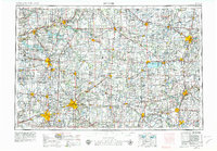
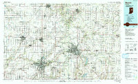
1956 Map of Muncie
USGS Topo · Published 1956About this map
Muncie and the surrounding industrial corridor of eastern Indiana and western Ohio appear here during a period of significant post-war connectivity. The landscape is defined by an incredibly dense network of competing rail lines, including the Pennsylvania RR, New York Central RR, and the Chesapeake & Ohio RR, which linked manufacturing hubs like Anderson, Marion, and Lima. This 1950s survey captures the region just before the interstate highway system transformed these traditional transit corridors.
Find a feature on this map
383 named features on this map. Tap any name to fly to it.
Don’t see what you’re looking for? This feature index may not catch every label — zoom into the map to look around manually.
Map Details
Editions of this 1956 Muncie Map
This is the sole edition of this map. No revisions or reprints were ever made.
Historical Maps of Fort Wayne Through Time
3 maps found