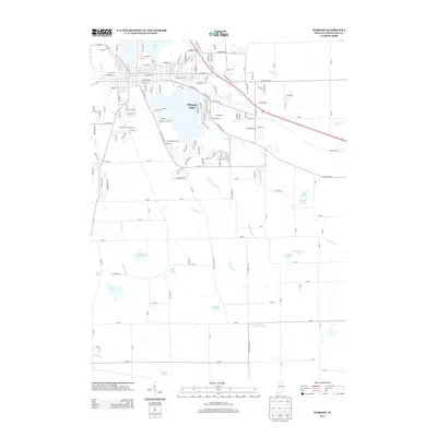
2013 Map of Warsaw
USGS Topo · Published 2013About this map
Winona Lake and its surrounding residential streets anchor the northern portion of this Kosciusko County landscape, where the town's grid meets a dense network of glacial water bodies and drainage systems. This 2013 survey reveals an intricate hydrological pattern defined by modern channelization, including the Wyland Ditch, Keefer-Evans Ditch, and Peterson Ditch, which manage the low-lying terrain between scattered lakes. To the south, the landscape becomes increasingly dominated by these natural basins, featuring Muskellunge Lake, Fish Lake, and Schultz Lake. The mapping captures the transition from the developed core near Pike Lake to the more open, wetland-influenced areas where smaller bodies like Read Lake and Carr Lake remain. The road network, including E Winona Ave and Rozella Rd, connects these waterscapes, illustrating how the region's geography has been shaped by both natural lake formations and extensive agricultural drainage engineering.
Find a feature on this map
172 named features on this map. Tap any name to fly to it.
Don’t see what you’re looking for? This feature index may not catch every label — zoom into the map to look around manually.
Map Details
Editions of this 2013 Warsaw Map
This is the sole edition of this map. No revisions or reprints were ever made.
Other maps of this area

1950 · Leesburg
USGS Topo · 1:24,000

1950 · Pierceton
USGS Topo · 1:24,000

1950 · North Webster
USGS Topo · 1:24,000

1953 · Fort Wayne
USGS Topo · 1:250,000

1956 · Fort Wayne
USGS Topo · 1:250,000

1957 · Warsaw
USGS Topo · 1:24,000

1959 · Atwood
USGS Topo · 1:24,000

1961 · Silver Lake
USGS Topo · 1:24,000
1961 · Burket
USGS Topo · 1:24,000
1962 · North Manchester North
USGS Topo · 1:24,000