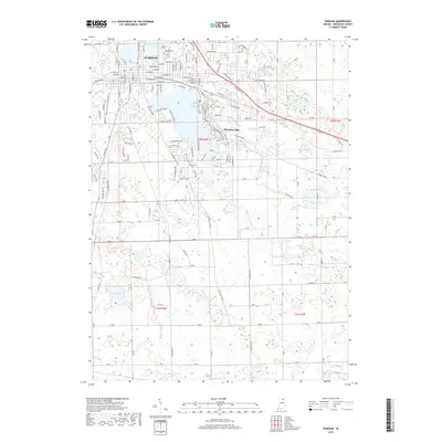
2019 Map of Warsaw
USGS Topo · Published 2019About this map
Warsaw anchors this modern survey of northern Indiana, where the urban grid of the county seat transitions into a complex glacial landscape of interconnected wetlands and lakes. To the north, Pike Lake and the expansive Oakwood Cemetery define the town's edge, while the town of Winona Lake sits to the east, bordered by the Heritage Trail and Main Basic Trail. The drainage patterns of the region are exceptionally well-defined, showing how Eagle Creek and Walnut Creek move through the terrain alongside man-made improvements like the Peterson Ditch and Wyland Ditch. To the south and east, the landscape becomes increasingly rural, dotted with smaller water bodies such as Carr Lake, Fish Lake, and McPherson Lake. This map captures the modern balance between residential growth in the lakeland corridor and the surrounding agricultural tracts defined by the townships of t32n r6e and t31n r7e.
Find a feature on this map
150 named features on this map. Tap any name to fly to it.
Don’t see what you’re looking for? This feature index may not catch every label — zoom into the map to look around manually.
Map Details
Editions of this 2019 Warsaw Map
This is the sole edition of this map. No revisions or reprints were ever made.
Other maps of this area

1950 · Leesburg
USGS Topo · 1:24,000

1950 · Pierceton
USGS Topo · 1:24,000

1950 · North Webster
USGS Topo · 1:24,000

1953 · Fort Wayne
USGS Topo · 1:250,000

1956 · Fort Wayne
USGS Topo · 1:250,000

1957 · Warsaw
USGS Topo · 1:24,000

1959 · Atwood
USGS Topo · 1:24,000

1961 · Silver Lake
USGS Topo · 1:24,000
1961 · Burket
USGS Topo · 1:24,000
1962 · North Manchester North
USGS Topo · 1:24,000