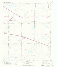
1956 Map of Washburn
USGS Topo · Published 1975About this map
The settlement of Washburn and the small station of Yarnall define this Panhandle landscape at the intersection of early Texas rail corridors and modern highway expansion. A 1956 ground survey, updated with aerial observations through 1973, details the rail-driven geography where the Chicago Rock Island and Pacific and the Fort Worth and Denver lines cut across the plains. These tracks were instrumental in establishing the region as a shipping point for the surrounding cattle and agricultural land. South of the townsite, the terrain descends toward Mulberry Creek, showing the transition from the flat high plains to the drainage breaks. For those researching local roots, the Washburn Cem is clearly marked, and the map provides an exacting look at the boundaries between Potter, Carson, Randall, and Armstrong counties.
Find a feature on this map
10 named features on this map. Tap any name to fly to it.
Don’t see what you’re looking for? This feature index may not catch every label — zoom into the map to look around manually.
Map Details
Editions of this 1956 Washburn Map
3 editions found
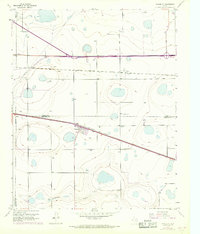
Other maps of this area

1953 · Mayer
USGS Topo · 1:24,000

1953 · Sevenmile Basin
USGS Topo · 1:24,000

1954 · Amarillo
USGS Topo · 1:250,000

1956 · Washburn
USGS Topo · 1:24,000

1956 · Thomas Ranch
USGS Topo · 1:24,000

1956 · Pullman
USGS Topo · 1:24,000

1958 · Amarillo
USGS Topo · 1:250,000

1960 · Fairview
USGS Topo · 1:24,000

1960 · Claude
USGS Topo · 1:62,500

1966 · Panhandle West
USGS Topo · 1:24,000