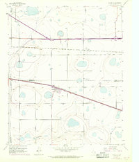
1956 Map of Washburn
USGS Topo · Published 1968About this map
Washburn sits at the junction of two major rail systems, the Fort Worth and Denver and the Chicago Rock Island and Pacific, highlighting its role as a Panhandle transportation hub. This 1950s landscape, later updated in the late 1960s, reveals a terrain defined by numerous depressions and catchments typical of the Llano Estacado. The settlement pattern is concentrated near the tracks, where the Washburn Cem and a grid of residential streets appear alongside significant infrastructure, including a prominent Telegraph Line and a large Pipeline crossing the northern plains. In the south, the headwaters of Mulberry Creek begin to carve through the level plateau, providing a rare break in the flat topography. The map also documents the arrival of modern highway engineering, with a section of road marked as Under Construction in the northwest corner, signaling the shift from rail to interstate travel.
Find a feature on this map
14 named features on this map. Tap any name to fly to it.
Don’t see what you’re looking for? This feature index may not catch every label — zoom into the map to look around manually.
Map Details
Editions of this 1956 Washburn Map
3 editions found
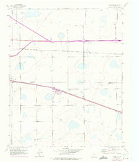
Other maps of this area

1953 · Mayer
USGS Topo · 1:24,000

1953 · Sevenmile Basin
USGS Topo · 1:24,000

1954 · Amarillo
USGS Topo · 1:250,000

1956 · Washburn
USGS Topo · 1:24,000

1956 · Thomas Ranch
USGS Topo · 1:24,000

1956 · Pullman
USGS Topo · 1:24,000

1958 · Amarillo
USGS Topo · 1:250,000

1960 · Fairview
USGS Topo · 1:24,000

1960 · Claude
USGS Topo · 1:62,500

1966 · Panhandle West
USGS Topo · 1:24,000