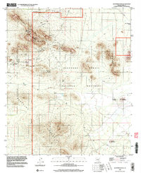
1996 Map of Waterman Peak
USGS Topo · Published 2003About this map
The Waterman Mountains dominate this high-desert landscape in Pima County, rising toward the prominent Waterman Peak. Much of the terrain is defined by the Ironwood Forest National Monument, which protects a distinct botanical and geological environment. The map details an area of transition between federal lands and the Tohono O'odham Indian Reservation Boundary to the west, where the Roskruge Mountains begin their ascent.
Find a feature on this map
20 named features on this map. Tap any name to fly to it.
Don’t see what you’re looking for? This feature index may not catch every label — zoom into the map to look around manually.
Map Details
Editions of this 1996 Waterman Peak Map
This is the sole edition of this map. No revisions or reprints were ever made.
Other maps of this area

1934 · Tucson Mountains
USGS Topo · 1:125,000

1934 · Silver Bell
USGS Topo · 1:125,000

1938 · San Vicente
USGS Topo · 1:62,500

1941 · San Vicente
USGS Topo · 1:62,500

1941 · Cocoraque Butte
USGS Topo · 1:62,500

1942 · San Vicente
USGS Topo · 1:62,500

1943 · Cocoraque Butte
USGS Topo · 1:62,500

1948 · San Vicente
USGS Topo · 1:62,500

1956 · Tucson
USGS Topo · 1:250,000

1958 · Tucson
USGS Topo · 1:250,000