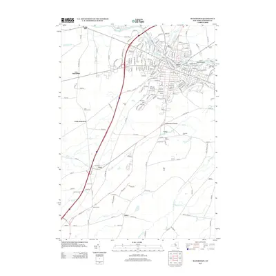
2013 Map of Watertown
USGS Topo · Published 2013About this map
The Black River carves a distinctive industrial and topographical path through this area, creating several notable landforms including Beebee's Island, Sewalls Island, and Diamond Island. These islands, historically central to the power and development of the city, sit near the Watertown Water Works. The urban grid transitions into the surrounding countryside, where small settlements like East Hounsfield, Fields Settlement, and Rices maintain their identities.
Find a feature on this map
209 named features on this map. Tap any name to fly to it.
Don’t see what you’re looking for? This feature index may not catch every label — zoom into the map to look around manually.
Map Details
Editions of this 2013 Watertown Map
This is the sole edition of this map. No revisions or reprints were ever made.
Other maps of this area

1893 · Sackets Harbor
USGS Topo · 1:62,500

1895 · Sacketts Harbor
USGS Topo · 1:62,500

1895 · Watertown
USGS Topo · 1:62,500

1898 · Watertown
USGS Topo · 1:62,500

1900 · Clayton
USGS Topo · 1:62,500

1903 · Clayton
USGS Topo · 1:62,500

1903 · Theresa
USGS Topo · 1:62,500

1908 · Watertown
USGS Topo · 1:62,500

1909 · Watertown
USGS Topo · 1:62,500
1943 · Sackets Harbor
USGS Topo · 1:31,680