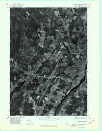
1975 Map of Waterville SW
USGS Topo · Published 1980About this map
Waterville and Oakland anchor this mid-1970s orthophotographic study, showing the dense development and industrial patterns of Kennebec County as they existed several decades ago. The imagery reveals the significant relationship between the local economy and the region's waterways, particularly the Kennebec River which forms the eastern boundary of the quadrangle. North of the primary urban centers, the landscape transitions into the smaller rural settlement of Fairfield Center, where cleared agricultural fields contrast with the heavily wooded tracts common to this part of Maine. This aerial perspective captures the intricate hydrology of the area, tracing the flow of Messalonskee Stream from the southern tip of Messalonskee Lake as it winds toward its confluence, alongside the smaller Martin Stream in the northwestern sector.
Find a feature on this map
7 named features on this map. Tap any name to fly to it.
Don’t see what you’re looking for? This feature index may not catch every label — zoom into the map to look around manually.
Map Details
Editions of this 1975 Waterville SW Map
This is the sole edition of this map. No revisions or reprints were ever made.
Other maps of this area

1892 · Waterville
USGS Topo · 1:62,500

1892 · Augusta
USGS Topo · 1:62,500

1893 · Vassalboro
USGS Topo · 1:62,500

1894 · Norridgewock
USGS Topo · 1:62,500

1898 · Norridgewock
USGS Topo · 1:62,500

1898 · Vassalboro
USGS Topo · 1:62,500

1941 · Vassalboro
USGS Topo · 1:62,500

1941 · Augusta
USGS Topo · 1:62,500

1943 · Augusta
USGS Topo · 1:62,500

1943 · Vassalboro
USGS Topo · 1:62,500