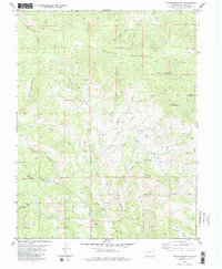
1983 Map of Waugh Mountain
USGS Topo · Published 1983About this map
Waugh Mountain dominates the high-altitude terrain of Fremont County, anchoring a landscape defined by dramatic elevation changes and a dense network of seasonal drainages. This 1983 edition, based on earlier field checks, details a remote region of the Colorado high country where resource extraction and ranching left subtle marks. A single Prospect in the south near Red Hill and a lone Corral near West Waugh Creek suggest the area's primary uses during the late twentieth century.
Find a feature on this map
29 named features on this map. Tap any name to fly to it.
Don’t see what you’re looking for? This feature index may not catch every label — zoom into the map to look around manually.
Map Details
Editions of this 1983 Waugh Mountain Map
2 editions found
Other maps of this area

1954 · Pueblo
USGS Topo · 1:250,000

1956 · Cameron Mountain
USGS Topo · 1:62,500

1957 · Pueblo
USGS Topo · 1:250,000

1958 · Pueblo
USGS Topo · 1:250,000

1959 · Black Mountain
USGS Topo · 1:62,500

1959 · Howard
USGS Topo · 1:62,500

1959 · Cotopaxi
USGS Topo · 1:62,500

1962 · Pueblo
USGS Topo · 1:250,000

1966 · Pueblo
USGS Topo · 1:250,000
1980 · Echo
USGS Topo · 1:24,000