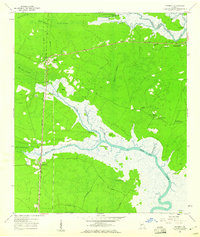
1959 Map of Waverly
USGS Topo · Published 1960About this map
White Oak Creek and the Little Satilla River dominate this coastal Georgia landscape, where the tides met a mid-century transportation corridor. In the late 1950s, the Seaboard Air Line railroad and the Ocean Highway ran parallel through the western settlements of Waverly and White Oak, serving as the primary arteries for this low-lying region. Between these rails and the sea lies a complex network of wetlands, including Glencoe Swamp and Canoe Swamp, punctuated by named high points such as Red Bluff and Goat Island. Local heritage is preserved in the placement of the Horse Stamp Ch and the Quarterman Cem, which sit atop the better-drained lands east of the main rail line. The presence of Sargs Landing and several river islands highlights the importance of small-craft navigation and river access in a period when the timber and coastal economy relied heavily on these intricate waterways.
Find a feature on this map
43 named features on this map. Tap any name to fly to it.
Don’t see what you’re looking for? This feature index may not catch every label — zoom into the map to look around manually.
Map Details
Editions of this 1959 Waverly Map
This is the sole edition of this map. No revisions or reprints were ever made.
Other maps of this area

1917 · Nahunta
USGS Topo · 1:62,500

1917 · Boulogne
USGS Topo · 1:62,500

1918 · Nahunta
USGS Topo · 1:62,500

1918 · Bladen
USGS Topo · 1:62,500

1918 · Kingsland
USGS Topo · 1:62,500

1919 · Boulogne
USGS Topo · 1:62,500

1939 · Bladen
USGS Topo · 1:62,500

1946 · Brunswick
USGS Topo · 1:250,000

1948 · Jacksonville
USGS Topo · 1:250,000

1948 · Brunswick
USGS Topo · 1:250,000