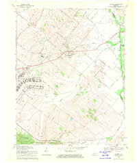
1969 Map of Waverly
USGS Topo · Published 1971About this map
Oil Wells dot the landscape of eastern Union County and western Henderson County, reflecting the deep integration of the petroleum industry into this rural Kentucky environment. The Illinois Central Railroad serves as a central artery through the quadrangle, passing through the town of Waverly and near St Vincent. Significant religious and educational institutions are concentrated here, most notably the St Vincent Academy and Sacred Heart Ch, which anchored the local community alongside St Peters Ch.
Find a feature on this map
53 named features on this map. Tap any name to fly to it.
Don’t see what you’re looking for? This feature index may not catch every label — zoom into the map to look around manually.
Map Details
Editions of this 1969 Waverly Map
This is the sole edition of this map. No revisions or reprints were ever made.
Other maps of this area

1906 · Sebree
USGS Topo · 1:62,500

1907 · Morganfield
USGS Topo · 1:62,500

1914 · Henderson
USGS Topo · 1:48,000

1916 · Henderson
USGS Topo · 1:62,500

1917 · Uniontown
USGS Topo · 1:62,500

1949 · Morganfield
USGS Topo · 1:24,000

1949 · Poole
USGS Topo · 1:24,000

1951 · Dixon
USGS Topo · 1:24,000

1951 · Poole
USGS Topo · 1:24,000

1951 · Waverly
USGS Topo · 1:24,000