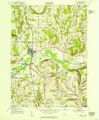
1953 Map of Wayland
USGS Topo · Published 1953About this map
The village of Wayland serves as a busy crossroads for the New York southern tier in the mid-20th century, situated where the Erie and Delaware Lackawanna and Western railroads converge. The grid of the village is clearly defined, featuring Victory Park and St Josephs church, while the surrounding landscape is marked by a high density of rural schoolhouses and family-named cemeteries.
Find a feature on this map
64 named features on this map. Tap any name to fly to it.
Don’t see what you’re looking for? This feature index may not catch every label — zoom into the map to look around manually.
Map Details
Editions of this 1953 Wayland Map
This is the sole edition of this map. No revisions or reprints were ever made.
Other maps of this area

1900 · Naples
USGS Topo · 1:62,500

1902 · Wayland
USGS Topo · 1:62,500

1903 · Naples
USGS Topo · 1:62,500

1904 · Wayland
USGS Topo · 1:62,500

1910 · Bath
USGS Topo · 1:62,500

1913 · Naples
USGS Topo · 1:62,500

1915 · Hornell
USGS Topo · 1:62,500

1918 · Hornell
USGS Topo · 1:62,500

1942 · Springwater
USGS Topo · 1:31,680

1942 · Wayland
USGS Topo · 1:31,680