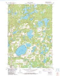
1982 Map of Webster
USGS Topo · Published 1983About this map
Devils Lake dominates the central landscape of this Burnett County survey, surrounded by a dense network of smaller water bodies including Johnson Lake, Ham Lake, and the expansive Yellow Lake to the west. The village of Webster occupies the southwestern corner, serving as a hub for the surrounding townships of Meenon and Oakland. The area's social and community history is anchored by several rural burying grounds such as Oak Grove Cem and Oakland Cem, while the northern reaches near the Danbury Dam reflect the region's managed waterways. To the southeast, the Kiezer Lake State Public Hunting Grounds preserves a mosaic of wetlands and timber. The presence of the Danbury Lookout Tower and scattered Gravel Pits suggests an economy balanced between timber management, conservation, and local resource extraction.
Find a feature on this map
53 named features on this map. Tap any name to fly to it.
Don’t see what you’re looking for? This feature index may not catch every label — zoom into the map to look around manually.
Map Details
Editions of this 1982 Webster Map
This is the sole edition of this map. No revisions or reprints were ever made.
Other maps of this area

1949 · Danbury
USGS Topo · 1:48,000

1949 · Hertel
USGS Topo · 1:48,000

1949 · Webb Lake
USGS Topo · 1:48,000

1950 · Webster
USGS Topo · 1:48,000

1953 · Duluth
USGS Topo · 1:250,000

1953 · Stillwater
USGS Topo · 1:250,000

1955 · Hertel
USGS Topo · 1:62,500

1955 · Webb Lake
USGS Topo · 1:62,500

1955 · Webster
USGS Topo · 1:62,500

1955 · Stillwater
USGS Topo · 1:250,000