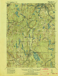
1921 Map of Webster
USGS Topo · Published 1921About this map
The French River corridor and its industrial mill towns define this early twentieth-century landscape south of Worcester. Centered on the growing hub of Webster, the map illustrates a complex network of reservoirs and ponds like Singletary Pond and Stiles Reservoir that once powered the region’s early manufacturing districts. The rail infrastructure is remarkably dense, featuring the Norwich and Worcester R.R. and the Boston and Albany R.R., which linked small industrial villages such as Rochdale, Charlton Depot, and Bramanville. Extensive field work by the Corps of Engineers in 1915 and 1918 captured a highly detailed topographic view of the tri-state border region where Massachusetts, Connecticut, and Rhode Island meet. Local heights including Mt Ararat and Dresser Hill rise above the valleys, framing a landscape where agricultural heritage met the rapid expansion of the steam and water-powered economy.
Find a feature on this map
118 named features on this map. Tap any name to fly to it.
Don’t see what you’re looking for? This feature index may not catch every label — zoom into the map to look around manually.
Map Details
Editions of this 1921 Webster Map
This is the sole edition of this map. No revisions or reprints were ever made.
Other maps of this area

1885 · Worcester
USGS Topo · 1:62,500

1886 · Worcester
USGS Topo · 1:62,500

1886 · Blackstone
USGS Topo · 1:62,500

1887 · Brookfield
USGS Topo · 1:62,500

1887 · Marlboro
USGS Topo · 1:62,500

1887 · Barre
USGS Topo · 1:62,500

1889 · Marlboro
USGS Topo · 1:62,500

1889 · Blackstone
USGS Topo · 1:62,500

1889 · Webster
USGS Topo · 1:62,500

1889 · Putnam
USGS Topo · 1:62,500