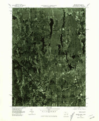
1975 Map of Webster
USGS Topo · Published 1981About this map
Webster and its surrounding textile-mill landscape appear in this mid-1970s orthophotograph, captured by the U.S. Geological Survey and the Commonwealth of Massachusetts Department of Public Works. The imagery reveals the dense industrial and residential core of Dudley and the manufacturing centers along the French River, including the riverbank settlements of Perryville and Wilsonville. Unlike traditional topographic maps, this aerial perspective provides a literal view of the land-use patterns during this era, showing the distinct contrast between the built-up valley floors and the wooded uplands of South Charlton and Oxford. To the southwest, the Quinebaug River winds through the village of Quinebaug, marking the transition across the state line into Connecticut. Researchers can clearly identify the footprint of 1970s development, from the established mill towns to the expanding suburban clearing and field boundaries that defined the Worcester County landscape of the time.
Find a feature on this map
9 named features on this map. Tap any name to fly to it.
Don’t see what you’re looking for? This feature index may not catch every label — zoom into the map to look around manually.
Map Details
Editions of this 1975 Webster Map
This is the sole edition of this map. No revisions or reprints were ever made.
Other maps of this area

1887 · Brookfield
USGS Topo · 1:62,500

1889 · Webster
USGS Topo · 1:62,500

1889 · Putnam
USGS Topo · 1:62,500

1890 · Brookfield
USGS Topo · 1:62,500

1892 · Woodstock
USGS Topo · 1:62,500

1892 · Webster
USGS Topo · 1:62,500

1893 · Putnam
USGS Topo · 1:62,500

1893 · Brookfield
USGS Topo · 1:62,500

1908 · Quinsigamond
USGS Topo · 1:125,000

1908 · Ware
USGS Topo · 1:125,000