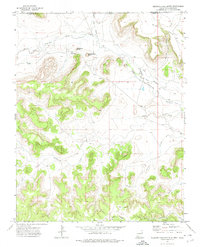
1972 Map of Wedding Cake Butte
USGS Topo · Published 1974About this map
Wedding Cake Butte rises as a distinctive landmark above the high plains of the Union County panhandle, where the New Mexico border meets Colorado. This arid landscape is defined by the winding course of the Dry Cimarron River and its accompanying irrigation systems, including the North Beheimer Ditch and Roberts Ditch, which supported ranching operations in this isolated corner of the territory. Small ranching nodes like Sloan, Bontz, and Cochrane are visible, alongside a cemetery and Prospect site, hinting at the modest human footprint in this terrain of mesas and canyons.
Find a feature on this map
25 named features on this map. Tap any name to fly to it.
Don’t see what you’re looking for? This feature index may not catch every label — zoom into the map to look around manually.
Map Details
Editions of this 1972 Wedding Cake Butte Map
This is the sole edition of this map. No revisions or reprints were ever made.
Other maps of this area

1892 · Mt Carrizo
USGS Topo · 1:125,000

1954 · Dalhart
USGS Topo · 1:250,000

1955 · La Junta
USGS Topo · 1:250,000

1958 · La Junta
USGS Topo · 1:250,000

1958 · Dalhart
USGS Topo · 1:250,000

1962 · Dalhart
USGS Topo · 1:250,000

1968 · La Junta
USGS Topo · 1:250,000

1972 · Cuates School
USGS Topo · 1:24,000
1972 · Goodson School
USGS Topo · 1:24,000

1972 · Atencio
USGS Topo · 1:24,000