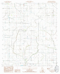
1985 Map of Welsh North
USGS Topo · Published 1985About this map
Bayou Lacassine meanders through this agricultural landscape in Jefferson Davis Parish, defining much of the drainage pattern south of the small settlement of Pine Island. This 1985 survey captures the area just north of the Welsh Corporate Boundary, where the terrain is dominated by an extensive network of flumes, siphons, and irrigation canals essential for local rice and crawfish farming. The landscape is largely rural, marked by isolated landmarks such as a Radio Tower and a quiet Cem located in the northwest. To the east, the winding path of Gum Gully cuts through the prairie, illustrating the natural watercourses that persist alongside the modern irrigation infrastructure that has reshaped this part of Louisiana.
Find a feature on this map
6 named features on this map. Tap any name to fly to it.
Don’t see what you’re looking for? This feature index may not catch every label — zoom into the map to look around manually.
Map Details
Editions of this 1985 Welsh North Map
This is the sole edition of this map. No revisions or reprints were ever made.
Other maps of this area

1946 · Lacassine
USGS Topo · 1:31,680

1946 · Jennings
USGS Topo · 1:31,680

1947 · Kinder
USGS Topo · 1:31,680

1947 · Fenton
USGS Topo · 1:31,680

1947 · Pine Island
USGS Topo · 1:31,680

1947 · Welsh
USGS Topo · 1:31,680

1947 · Elton
USGS Topo · 1:31,680

1947 · Edna
USGS Topo · 1:31,680

1947 · Hathaway
USGS Topo · 1:31,680

1950 · Fenton
USGS Topo · 1:31,680