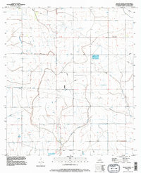
1994 Map of Welsh North
USGS Topo · Published 1996About this map
The settlement of Pine Island sits within a landscape defined by water management and industrial infrastructure in the mid-1990s. The northern reaches of the area are marked by an extensive network of pipelines and a prominent Levee system, reflecting the region's intersection with the energy sector. In the southern portion of the sheet, the Welsh Corporate Boundary delineates the northern edge of the township, while the winding course of East Bayou Lacassine provides a natural contrast to the grid-like surveying lines of the Jefferson Davis Parish interior. Local landmarks like the Substation and multiple installations of a Comm Tower anchor the rural landscape, offering specific points of reference for those tracing historical land use or utility developments. Small features like a local Cem and the drainage of Gum Gully further characterize this corner of Louisiana as it transitioned toward the turn of the twenty-first century.
Find a feature on this map
10 named features on this map. Tap any name to fly to it.
Don’t see what you’re looking for? This feature index may not catch every label — zoom into the map to look around manually.
Map Details
Editions of this 1994 Welsh North Map
This is the sole edition of this map. No revisions or reprints were ever made.
Other maps of this area

1946 · Lacassine
USGS Topo · 1:31,680

1946 · Jennings
USGS Topo · 1:31,680

1947 · Kinder
USGS Topo · 1:31,680

1947 · Fenton
USGS Topo · 1:31,680

1947 · Pine Island
USGS Topo · 1:31,680

1947 · Welsh
USGS Topo · 1:31,680

1947 · Elton
USGS Topo · 1:31,680

1947 · Edna
USGS Topo · 1:31,680

1947 · Hathaway
USGS Topo · 1:31,680

1950 · Fenton
USGS Topo · 1:31,680