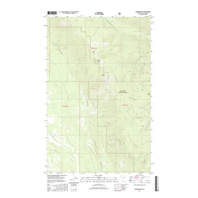
2017 Map of Werner Peak
USGS Topo · Published 2017About this map
Werner Peak rises as a central landmark within the Whitefish Range on this 2017 study of Flathead National Forest. The landscape is defined by its complex drainage network, where Hallowat Cr, Swift Cr, and Nicola Cr carve through high-elevation terrain. This modern USGS survey meticulously documents the extensive forest management infrastructure, illustrating how the Upper Whitefish Rd and various National Forest Development Roads navigate the steep topography.
Find a feature on this map
46 named features on this map. Tap any name to fly to it.
Don’t see what you’re looking for? This feature index may not catch every label — zoom into the map to look around manually.
Map Details
Editions of this 2017 Werner Peak Map
This is the sole edition of this map. No revisions or reprints were ever made.
Other maps of this area

1906 · Kintla Lakes
USGS Topo · 1:125,000

1913 · Stryker
USGS Topo · 1:125,000

1916 · Stryker
USGS Topo · 1:125,000

1938 · Kintla Lakes
USGS Topo · 1:125,000

1943 · Kalispell
USGS Topo · 1:125,000

1957 · Kalispell
USGS Topo · 1:250,000

1960 · Kalispell
USGS Topo · 1:250,000

1961 · Kalispell
USGS Topo · 1:250,000

1962 · Beaver Lake
USGS Topo · 1:24,000
1962 · Tally Lake
USGS Topo · 1:24,000