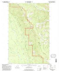
1994 Map of Werner Peak
USGS Topo · Published 1997About this map
The Whitefish Range dominates this mid-1990s survey, marking a significant borderland between the Stillwater State Forest and the Flathead National Forest. This high-elevation terrain is centered on the prominent Werner Peak, which features a recorded lookout station. The landscape is defined by its complex drainage systems, where the Middle Fork Swift Creek and Lazy Creek carve through the western slopes while Werner Creek flows toward the east. Human presence is largely limited to recreational and industrial access, including the Ralph Thayer Memorial Trail and a remote prospect site. The map captures the alignment of the Eighth Standard Parallel North as it cuts across the ridgelines, providing a technical look at how this wilderness was managed and partitioned for forestry and conservation near the end of the 20th century.
Find a feature on this map
22 named features on this map. Tap any name to fly to it.
Don’t see what you’re looking for? This feature index may not catch every label — zoom into the map to look around manually.
Map Details
Editions of this 1994 Werner Peak Map
This is the sole edition of this map. No revisions or reprints were ever made.
Other maps of this area

1906 · Kintla Lakes
USGS Topo · 1:125,000

1913 · Stryker
USGS Topo · 1:125,000

1916 · Stryker
USGS Topo · 1:125,000

1938 · Kintla Lakes
USGS Topo · 1:125,000

1943 · Kalispell
USGS Topo · 1:125,000

1957 · Kalispell
USGS Topo · 1:250,000

1960 · Kalispell
USGS Topo · 1:250,000

1961 · Kalispell
USGS Topo · 1:250,000

1962 · Beaver Lake
USGS Topo · 1:24,000
1962 · Tally Lake
USGS Topo · 1:24,000