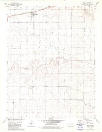
1979 Map of Weskan
USGS Topo · Published 1980About this map
Weskan serves as the central hub of this High Plains landscape, situated along the Union Pacific railroad corridor. The settlement is defined by its transit-oriented layout, featuring a prominent Water Tank and nearby Weskan Cem. Outside of the town center, the terrain is shaped by the drainage patterns of Eagletail Creek and the meandering Ladder Creek, which winds through the central portion of the quadrangle. To the south, the topographic character shifts near Rock Hill and the Middle Ladder Fk, where the map reveals a network of dispersed wells and water sources essential for life in Wallace County. The survey illustrates the intersection of industrial rail infrastructure with a traditional prairie agricultural system, capturing the area just as the 1970s concluded.
Find a feature on this map
12 named features on this map. Tap any name to fly to it.
Don’t see what you’re looking for? This feature index may not catch every label — zoom into the map to look around manually.
Map Details
Editions of this 1979 Weskan Map
This is the sole edition of this map. No revisions or reprints were ever made.
Other maps of this area

1892 · Cheyenne Wells
USGS Topo · 1:125,000

1894 · Cheyenne Wells
USGS Topo · 1:125,000

1954 · Lamar
USGS Topo · 1:250,000

1955 · Scott City
USGS Topo · 1:250,000

1958 · Lamar
USGS Topo · 1:250,000

1958 · Scott City
USGS Topo · 1:250,000

1959 · Weskan
USGS Topo · 1:62,500

1968 · Sharon Springs 3 NE
USGS Topo · 1:24,000

1968 · Sharon Springs 3 NW
USGS Topo · 1:24,000

1969 · Arapahoe SE
USGS Topo · 1:24,000