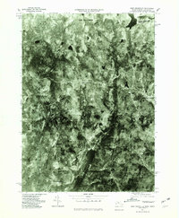
1975 Map of West Granville
USGS Topo · Published 1981About this map
West Granville and Granville Center anchor this mid-1970s orthophoto study of the Massachusetts-Connecticut borderlands. Captured during the peak of autumn in 1975, the aerial imagery reveals a landscape defined by significant water management infrastructure. Large impoundments, including the Cobble Mountain Reservoir in the northeast and the Barkhamsted Reservoir to the south, dominate the terrain. These reservoirs are fed by systems like the East Branch Farmington River and Little River, which carve through the wooded uplands. Settlement patterns are concentrated along historic crossroads, such as Baird Four Corners and the community of West Hartland just across the state line. The orthophoto format provides a unique view of field boundaries and forest density that traditional line-drawn maps often obscure, offering researchers a clear look at land use during this era.
Find a feature on this map
8 named features on this map. Tap any name to fly to it.
Don’t see what you’re looking for? This feature index may not catch every label — zoom into the map to look around manually.
Map Details
Editions of this 1975 West Granville Map
This is the sole edition of this map. No revisions or reprints were ever made.
Other maps of this area

1887 · Granville
USGS Topo · 1:62,500

1888 · Sandisfield
USGS Topo · 1:62,500

1889 · Granville
USGS Topo · 1:62,500

1892 · Winsted
USGS Topo · 1:62,500

1892 · Granby
USGS Topo · 1:62,500

1893 · Granville
USGS Topo · 1:62,500

1893 · Sandisfield
USGS Topo · 1:62,500

1895 · Granville
USGS Topo · 1:62,500

1896 · Holyoke
USGS Topo · 1:125,000

1897 · Sandisfield
USGS Topo · 1:62,500