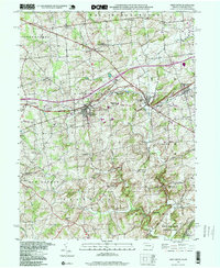
1997 Map of West Grove
USGS Topo · Published 1999About this map
Avondale and West Grove serve as the primary hubs in this corner of Chester County, where the historic Baltimore Pike and the Penn Central rail line cut across the rolling landscape. The map reveals a dense network of township boundaries, including Londonderry, London Grove, and New London, reflecting a long-established pattern of rural land division. This late-twentieth-century update shows the preservation of the southern landscape through the White Clay Creek State Preserve and White Clay Cr State Pk near the Delaware border.
Find a feature on this map
46 named features on this map. Tap any name to fly to it.
Don’t see what you’re looking for? This feature index may not catch every label — zoom into the map to look around manually.
Map Details
Editions of this 1997 West Grove Map
This is the sole edition of this map. No revisions or reprints were ever made.
Other maps of this area

1898 · Elkton
USGS Topo · 1:62,500

1900 · Elkton
USGS Topo · 1:62,500

1901 · West Chester
USGS Topo · 1:62,500

1904 · West Chester
USGS Topo · 1:62,500

1904 · Coatesville
USGS Topo · 1:62,500

1904 · Wilmington
USGS Topo · 1:62,500

1906 · Coatesville
USGS Topo · 1:62,500

1906 · Wilmington
USGS Topo · 1:62,500

1917 · Elkton
USGS Topo · 1:62,500

1918 · Coatesville
USGS Topo · 1:62,500
Featured Places
- New Garden Township, PA
- New London Township, PA
- Franklin Township, PA
- Toughkenamon, New Garden Township
- North Star, Delaware, DE