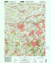
1999 Map of West Grove
USGS Topo · Published 2001About this map
West Grove and the surrounding Chester County countryside are defined by a complex network of waterways, including the three primary branches of White Clay Creek. At the close of the 20th century, the landscape preserved a dense collection of rural institutions and small settlements connected by the Baltimore Pike. Significant civic markers include the New London Academy and Avon Grove High Sch, alongside numerous smaller schoolhouses such as Auburn Sch and Maple Grove Sch. The area's spiritual and community life is anchored by locations like the Episcopal Ch and St Marys Cem. Moving south toward the White Clay Creek State Preserve, the terrain becomes more varied as it follows the winding paths of Broad Run and Egypt Run. This survey offers a detailed view of the region's transition from historic villages like London Grove and Chatham to the larger centers of Avondale and Toughkenamon.
Find a feature on this map
45 named features on this map. Tap any name to fly to it.
Don’t see what you’re looking for? This feature index may not catch every label — zoom into the map to look around manually.
Map Details
Editions of this 1999 West Grove Map
This is the sole edition of this map. No revisions or reprints were ever made.
Other maps of this area

1898 · Elkton
USGS Topo · 1:62,500

1900 · Elkton
USGS Topo · 1:62,500

1901 · West Chester
USGS Topo · 1:62,500

1904 · West Chester
USGS Topo · 1:62,500

1904 · Coatesville
USGS Topo · 1:62,500

1904 · Wilmington
USGS Topo · 1:62,500

1906 · Coatesville
USGS Topo · 1:62,500

1906 · Wilmington
USGS Topo · 1:62,500

1917 · Elkton
USGS Topo · 1:62,500

1918 · Coatesville
USGS Topo · 1:62,500
Featured Places
- New Garden Township, PA
- New London Township, PA
- Franklin Township, PA
- Toughkenamon, New Garden Township
- North Star, Delaware, DE