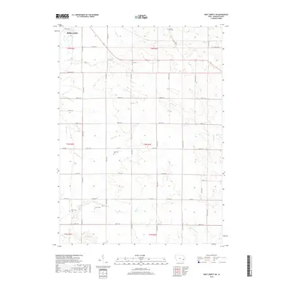
2018 Map of West Liberty SW
USGS Topo · Published 2018About this map
Iowa City extends into the northwest corner of this landscape, where the urban grid gives way to the section-line roads of Johnson County. The area is defined by a dense network of small family and farm burial grounds, including the Molback Farm Cem and Scott Cem in the north, and Walker Cem and Fountain Cem further south. These sites, along with the centrally located Trowbridge Cem, reflect a deeply established pattern of rural settlement and local genealogy. The terrain is shaped by the winding paths of Snyder Cr and Pechman Cr, which feed into larger drainages like Big Slough. The rural character is reinforced by long-standing east-west thoroughfares such as 480th St SE and Co Rd F63, which partition the agricultural landscape into orderly townships.
Find a feature on this map
30 named features on this map. Tap any name to fly to it.
Don’t see what you’re looking for? This feature index may not catch every label — zoom into the map to look around manually.
Map Details
Editions of this 2018 West Liberty SW Map
This is the sole edition of this map. No revisions or reprints were ever made.
Other maps of this area

1891 · Iowa City
USGS Topo · 1:62,500

1894 · West Liberty
USGS Topo · 1:62,500

1901 · Stanwood
USGS Topo · 1:125,000

1903 · Fairfax
USGS Topo · 1:125,000

1938 · Iowa City
USGS Topo · 1:62,500

1958 · Davenport
USGS Topo · 1:250,000

1961 · Davenport
USGS Topo · 1:250,000

1962 · Davenport
USGS Topo · 1:250,000
1965 · West Liberty
USGS Topo · 1:24,000
1965 · Iowa City West
USGS Topo · 1:24,000