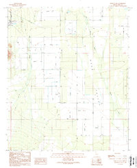
1989 Map of West of Avra
USGS Topo · Published 1989About this map
The Avra Valley defines this arid landscape, where the seasonal waters of Blanco Wash and Brawley Wash are redirected by an extensive system of irrigation infrastructure. This late 1980s data reveals a desert floor crisscrossed by an evolving network of water management, featuring numerous wells and a series of ditches, some of which are already marked as abandoned. Industrial and utility footprints are clear, from the Tucson Compressor Station in the northwest to the pipeline and power lines that traverse the valley. Small-scale aviation is represented by several landing strips, while the small settlement of Garcia and scattered structures along Manville Road provide points of reference for local historians studying rural expansion in Pima County.
Find a feature on this map
18 named features on this map. Tap any name to fly to it.
Don’t see what you’re looking for? This feature index may not catch every label — zoom into the map to look around manually.
Map Details
Editions of this 1989 West of Avra Map
This is the sole edition of this map. No revisions or reprints were ever made.
Other maps of this area

1925 · San Xavier
USGS Topo · 1:62,500

1934 · Tucson Mountains
USGS Topo · 1:125,000

1941 · Cocoraque Butte
USGS Topo · 1:62,500

1943 · Cocoraque Butte
USGS Topo · 1:62,500

1943 · San Xavier Mission
USGS Topo · 1:62,500

1947 · Cortaro
USGS Topo · 1:62,500

1956 · Tucson
USGS Topo · 1:250,000

1957 · San Xavier Mission
USGS Topo · 1:62,500

1957 · Cortaro
USGS Topo · 1:62,500

1958 · Tucson
USGS Topo · 1:250,000