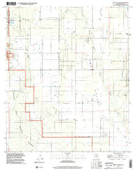
1996 Map of West of Avra
USGS Topo · Published 2002About this map
Avra Valley defines this arid landscape, where the seasonal flow of Brawley Wash and Blanco Wash dictates the drainage of the desert floor. During the late 1990s, this area of Pima County remained largely agricultural and utility-focused, marked by a complex network of ditches and pipelines supporting the regional infrastructure. The western edge is dominated by the Ironwood Forest National Monument, preserving the undisturbed character of the Sonoran Desert against the creeping utility development nearby. The infrastructure of the era is clearly visible through features like the Tucson Compressor Station and multiple Landing Strips, indicating the area's role in transportation and energy distribution. Smaller landmarks such as BK Tank and China Draw provide specific points of reference for those tracing the historical hydrology and land use patterns of this portion of the valley.
Find a feature on this map
14 named features on this map. Tap any name to fly to it.
Don’t see what you’re looking for? This feature index may not catch every label — zoom into the map to look around manually.
Map Details
Editions of this 1996 West of Avra Map
This is the sole edition of this map. No revisions or reprints were ever made.
Other maps of this area

1925 · San Xavier
USGS Topo · 1:62,500

1934 · Tucson Mountains
USGS Topo · 1:125,000

1941 · Cocoraque Butte
USGS Topo · 1:62,500

1943 · Cocoraque Butte
USGS Topo · 1:62,500

1943 · San Xavier Mission
USGS Topo · 1:62,500

1947 · Cortaro
USGS Topo · 1:62,500

1956 · Tucson
USGS Topo · 1:250,000

1957 · San Xavier Mission
USGS Topo · 1:62,500

1957 · Cortaro
USGS Topo · 1:62,500

1958 · Tucson
USGS Topo · 1:250,000