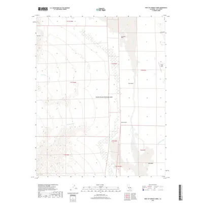
2018 Map of West of Furnace Creek
USGS Topo · Published 2018About this map
Cottonball Marsh and the surrounding alkaline flats of Cottonball Basin dominate this portion of Death Valley National Park. The landscape is defined by its extreme elevation changes, dropping from the high slopes of Tucki Mtn in the west down toward the Middle Basin in the east. Intermittent drainage patterns are clearly visible through Tucki Wash, Blackwater Wash, and Furnace Cr Wash, which convey seasonal runoff into the sink. Near the eastern edge, the Furnace Creek Airport stands as a rare piece of infrastructure in the desert, located just south of the winding walls of Mustard Canyon. The survey illustrates the geological complexity of the Mojave Desert floor, where Salt Creek meanders through the central valley, creating a unique hydrological environment at one of the lowest points in North America.
Find a feature on this map
21 named features on this map. Tap any name to fly to it.
Don’t see what you’re looking for? This feature index may not catch every label — zoom into the map to look around manually.
Map Details
Editions of this 2018 West of Furnace Creek Map
This is the sole edition of this map. No revisions or reprints were ever made.
Other maps of this area

1908 · Furnace Creek
USGS Topo · 1:250,000

1908 · Ballarat
USGS Topo · 1:250,000

1910 · Furnace Creek
USGS Topo · 1:250,000

1913 · Ballarat
USGS Topo · 1:250,000

1942 · Bullfrog
USGS Topo · 1:125,000

1948 · Death Valley
USGS Topo · 1:250,000

1952 · Chloride Cliff
USGS Topo · 1:50,000

1952 · Stovepipe Wells
USGS Topo · 1:62,500

1952 · Furnace Creek
USGS Topo · 1:62,500

1952 · Emigrant Canyon
USGS Topo · 1:62,500