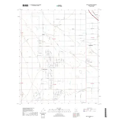
2018 Map of West of Marana
USGS Topo · Published 2018About this map
The Santa Cruz River defines the eastern corridor of this desert landscape, where the growing residential and agricultural fringes of Marana meet the sprawling basin of the Avra Valley. This 2018 survey reveals a complex network of ephemeral waterways, including the prominent Los Robles Wash and Brawley Wash, which channel seasonal runoff toward the river. The layout of the land is heavily influenced by large-scale sectioning and an extensive grid of local roads serving small desert settlements like Nelson and Dobson. To the north, Naviska sits near the rail line, while landmarks such as the Silverbell Road Bridge provide critical crossings over the often-dry washes. The map illustrates a contemporary period of expansion in Pima County, documenting the specific street names and property boundaries that characterize this modern desert community as it integrates with the natural drainage systems like China Draw and Blanco Wash.
Find a feature on this map
96 named features on this map. Tap any name to fly to it.
Don’t see what you’re looking for? This feature index may not catch every label — zoom into the map to look around manually.
Map Details
Editions of this 2018 West of Marana Map
This is the sole edition of this map. No revisions or reprints were ever made.
Other maps of this area

1934 · Tucson Mountains
USGS Topo · 1:125,000

1934 · Newman Peak
USGS Topo · 1:125,000

1947 · Cortaro
USGS Topo · 1:62,500

1947 · Red Rock
USGS Topo · 1:62,500

1956 · Tucson
USGS Topo · 1:250,000

1957 · Cortaro
USGS Topo · 1:62,500

1958 · Tucson
USGS Topo · 1:250,000

1959 · Tucson
USGS Topo · 1:250,000

1959 · Tortolita Mts
USGS Topo · 1:62,500
1959 · Silver Bell Peak
USGS Topo · 1:62,500