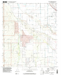
1996 Map of West of Marana
USGS Topo · Published 2002About this map
The Avra Valley desert landscape west of Marana is defined by an intricate network of desert watercourses that feed toward the Santa Cruz River in the northeast. This 1996 update reveals the established agricultural and residential grid south of the river, centered around the Avra Valley Sch and several prominent Gravel Pits. The western edge of the map transitions into the protected desert lands of the Ironwood Forest National Monument, where the terrain rises out of the valley floor. Transportation and infrastructure are anchored by the north-south corridors of Trico Road and Aguirre Road, while the settlement of Naviska sits near the northern boundary. The map provides a clear record of the intersection between human development, including extensive Pipelines, and the natural drainage systems like Brawley Wash and Robles Wash.
Find a feature on this map
21 named features on this map. Tap any name to fly to it.
Don’t see what you’re looking for? This feature index may not catch every label — zoom into the map to look around manually.
Map Details
Editions of this 1996 West of Marana Map
This is the sole edition of this map. No revisions or reprints were ever made.
Other maps of this area

1934 · Tucson Mountains
USGS Topo · 1:125,000

1934 · Newman Peak
USGS Topo · 1:125,000

1947 · Cortaro
USGS Topo · 1:62,500

1947 · Red Rock
USGS Topo · 1:62,500

1956 · Tucson
USGS Topo · 1:250,000

1957 · Cortaro
USGS Topo · 1:62,500

1958 · Tucson
USGS Topo · 1:250,000

1959 · Tucson
USGS Topo · 1:250,000

1959 · Tortolita Mts
USGS Topo · 1:62,500
1959 · Silver Bell Peak
USGS Topo · 1:62,500