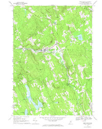
1967 Map of West Paris
USGS Topo · Published 1969About this map
West Paris serves as the focal point of this Oxford County landscape, where the Little Androscoggin River and the Grand Trunk railroad corridor dictate the valley's settlement patterns. The industrial and agricultural heritage of the late 1960s is evident in the numerous Gravel Pits and the Quarry near Woodstock, while smaller clusters like South Woodstock, North Paris, and Snow Falls maintain their distinct identities. Local history and genealogy are well-preserved through family-named landmarks and resting places such as Curtis Hill Cem, Tuell Cem, and Richardson Hollow Cem. The terrain is defined by significant elevations including Whitman Mtn, Stearns Hill, and Berry Ledge, which overlook water bodies like Moose Pond and the expansive Pennesseeewassee Lake to the southwest.
Find a feature on this map
53 named features on this map. Tap any name to fly to it.
Don’t see what you’re looking for? This feature index may not catch every label — zoom into the map to look around manually.
Map Details
Editions of this 1967 West Paris Map
This is the sole edition of this map. No revisions or reprints were ever made.
Other maps of this area

1896 · Norway
USGS Topo · 1:62,500

1908 · Poland
USGS Topo · 1:62,500

1911 · Bryant Pond
USGS Topo · 1:62,500

1911 · Buckfield
USGS Topo · 1:62,500

1913 · Buckfield
USGS Topo · 1:62,500

1914 · Bryant Pond
USGS Topo · 1:62,500

1940 · Poland
USGS Topo · 1:62,500

1942 · Buckfield
USGS Topo · 1:62,500

1942 · Bryant Pond
USGS Topo · 1:62,500

1942 · Poland
USGS Topo · 1:62,500