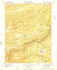
1949 Map of West Point
USGS Topo · Published 1949About this map
West Point and Wilseyville serve as central hubs in this postwar portrait of the Mother Lode’s rugged transition into the Mokelumne River canyon. The landscape is defined by the legacy of hydraulic and hard-rock mining, with numerous operations like the Black Prince Mine, Amador-Columbia Mine, and Yellow Aster Mine dotting the drainages. Water management is a dominant theme, illustrated by the complex systems of the Electra Canal and Lower Standard Canal that trace the steep contours of the river forks. This era shows the region balancing industrial utility with early recreation, as evidenced by Inspiration Lodge and Buckhorn Lodge alongside the Winton Lumber Co Road. The map also captures smaller, family-named pockets of settlement such as Bummerville and the Goodman Ranch, providing a detailed look at the scattered communities of Calaveras County before later 20th-century modernization.
Find a feature on this map
38 named features on this map. Tap any name to fly to it.
Don’t see what you’re looking for? This feature index may not catch every label — zoom into the map to look around manually.
Map Details
Editions of this 1949 West Point Map
This is the sole edition of this map. No revisions or reprints were ever made.
Other maps of this area

1889 · Jackson
USGS Topo · 1:125,000

1889 · Pyramid Peak
USGS Topo · 1:125,000

1891 · Big Trees
USGS Topo · 1:125,000

1891 · Placerville
USGS Topo · 1:125,000

1891 · Pyramid Peak
USGS Topo · 1:125,000

1892 · Jackson
USGS Topo · 1:125,000

1892 · Placerville
USGS Topo · 1:125,000

1893 · Placerville
USGS Topo · 1:125,000

1894 · Big Trees
USGS Topo · 1:125,000

1895 · Pyramid Peak
USGS Topo · 1:125,000