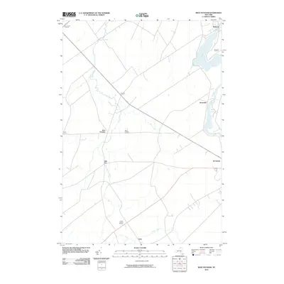
2010 Map of West Potsdam
USGS Topo · Published 2010About this map
The Raquette River shapes the eastern boundary of this region, flowing northward through the village of Norwood and the settlement of Hewittville. Away from the river, the landscape is defined by a network of agricultural crossroads and small hamlets, including West Potsdam, Burnham Corners, and the uniquely named Slab City. This 2010 survey illustrates the enduring rural character of Saint Lawrence County, where several small creeks like Trout Brook and Stony Brook meander through the farmland towards the river valley. Genealogists will find particular value in the clearly marked burial grounds distributed across the township, such as Saint James Cemetery in the northwest and the centrally located West Potsdam Cemetery. The map also captures the outskirts of the larger village of Potsdam in the southeast, providing a detailed look at the infrastructure connecting these historic North Country communities.
Find a feature on this map
16 named features on this map. Tap any name to fly to it.
Don’t see what you’re looking for? This feature index may not catch every label — zoom into the map to look around manually.
Map Details
Editions of this 2010 West Potsdam Map
This is the sole edition of this map. No revisions or reprints were ever made.
Other maps of this area

1905 · Waddington
USGS Topo · 1:62,500

1906 · Massena
USGS Topo · 1:62,500

1907 · Massena
USGS Topo · 1:62,500

1908 · Potsdam
USGS Topo · 1:62,500

1910 · Canton
USGS Topo · 1:62,500

1911 · Canton
USGS Topo · 1:62,500

1942 · Waddington
USGS Topo · 1:24,000

1942 · Chase Mills
USGS Topo · 1:24,000

1942 · Norfolk
USGS Topo · 1:24,000
1943 · Waddington
USGS Topo · 1:31,680