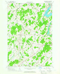
1964 Map of West Potsdam
USGS Topo · Published 1965About this map
The Raquette River flows along the eastern edge of this mid-1960s landscape, powering a corridor of development that includes Norwood and Hewittville. This survey shows a transition between industrial riverfront activity and the interior farm country of St. Lawrence County. Small hamlets like West Potsdam, Slab City, and Burnham Corners serve as local hubs, connected by a dense network of roads such as Finnegan Road and Lime Hollow Road. Local institutions like the Thompson Sch and Dailey Ridge Ch reflect the community life of the era.
Find a feature on this map
52 named features on this map. Tap any name to fly to it.
Don’t see what you’re looking for? This feature index may not catch every label — zoom into the map to look around manually.
Map Details
Editions of this 1964 West Potsdam Map
This is the sole edition of this map. No revisions or reprints were ever made.
Other maps of this area

1905 · Waddington
USGS Topo · 1:62,500

1906 · Massena
USGS Topo · 1:62,500

1907 · Massena
USGS Topo · 1:62,500

1908 · Potsdam
USGS Topo · 1:62,500

1910 · Canton
USGS Topo · 1:62,500

1911 · Canton
USGS Topo · 1:62,500

1942 · Waddington
USGS Topo · 1:24,000

1942 · Chase Mills
USGS Topo · 1:24,000

1942 · Norfolk
USGS Topo · 1:24,000
1943 · Waddington
USGS Topo · 1:31,680