1998 Map of West Swanzey
USGS Topo · Published 2002About this map
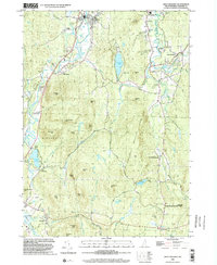
The Ashuelot River carves a path through the western half of this Cheshire County landscape, anchoring the village of West Swanzey. This era shows a community defined by its water-driven history and recreational shift, with Swanzey Lake and Forest Lake serving as prominent local landmarks. Education and civic life are centralized around Cutler Sch and the Monadnock Regional High Sch, while numerous Gravel Pits indicate active local industry.
Find a feature on this map
78 named features on this map. Tap any name to fly to it.
Don’t see what you’re looking for? This feature index may not catch every label — zoom into the map to look around manually.
Map Details
Editions of this 1998 West Swanzey Map
This is the sole edition of this map. No revisions or reprints were ever made.
Other maps of this area

1887 · Warwick
USGS Topo · 1:62,500

1887 · Winchendon
USGS Topo · 1:62,500

1889 · Warwick
USGS Topo · 1:62,500

1890 · Winchendon
USGS Topo · 1:62,500

1894 · Winchendon
USGS Topo · 1:62,500

1894 · Warwick
USGS Topo · 1:62,500

1898 · Monadnock
USGS Topo · 1:62,500

1898 · Keene
USGS Topo · 1:62,500

1932 · Warwick
USGS Topo · 1:48,000

1932 · Winchendon
USGS Topo · 1:48,000